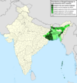
Dataja:Geographic distribution of Bengali language.png

Wulkosć tutoho přehlada: 800 × 593 pikselow. Druhe rozeznaća: 320 × 237 pikselow | 640 × 474 pikselow | 1.024 × 759 pikselow | 1.280 × 949 pikselow | 2.560 × 1.898 pikselow | 2.806 × 2.080 pikselow.
Wersija z wyšim rozeznaćom (2.806 × 2.080 pikselow, wulkosć dataje: 1,36 MB, typ MIME: image/png)
Wersije dataje
Klikń na wěsty čas, zo by wersiju dataje w tutym času zwobraznił.
| Čas | Wobrazowy napohlad | Rozeznaće | Wužiwar | Komentar | |
|---|---|---|---|---|---|
| aktualnje | 2. julija 2022, 17:05 |  | 2.806x2.080 (1,36 MB) | NikosLikomitros | A few districts of Arunachal Pradesh have a notable Bengali presence above of 1%, probably part of the Indian efforts to increase its presence in the region. |
| 1. julija 2022, 18:55 |  | 2.806x2.080 (1,36 MB) | NikosLikomitros | Two extra fixes. | |
| 1. julija 2022, 18:53 |  | 2.806x2.080 (1,36 MB) | NikosLikomitros | Minor fixes. | |
| 1. julija 2022, 18:44 |  | 2.806x2.080 (1,36 MB) | NikosLikomitros | Now, this map covers all districts of India. Includes also extra information and a new colour key. The basemap is from Distribution_of_Jats_in_South_Asia.png. | |
| 26. junija 2022, 23:09 |  | 1.902x2.048 (1.002 kB) | NikosLikomitros | Uploaded own work with UploadWizard |
Datajowe wužiwanje
Njejsu strony, kotrež tutu dataju wužiwaja.
Globalne wužiwanje dataje
Slědowace druhe wikije wužiwaja tutón wobraz:
- Wužiwanje na bn.wikipedia.org
- Wužiwanje na dv.wikipedia.org
- Wužiwanje na el.wikipedia.org
- Wužiwanje na en.wikipedia.org
- Wužiwanje na fa.wikipedia.org
- Wužiwanje na fr.wikipedia.org
- Wužiwanje na gl.wikipedia.org
- Wužiwanje na hi.wikipedia.org
