
Dataja:Asia 800ad.jpg
Wulkosć tutoho přehlada: 800 × 463 pikselow. Druhe rozeznaća: 320 × 185 pikselow | 640 × 370 pikselow | 1.024 × 593 pikselow | 1.280 × 741 pikselow | 2.099 × 1.215 pikselow.
Wersija z wyšim rozeznaćom (2.099 × 1.215 pikselow, wulkosć dataje: 809 kB, typ MIME: image/jpeg)

|
Dieses Bild des Typs Historical map sollte als Vektorgrafik im SVG-Format neu erstellt werden. Vektorformate haben zahlreiche Vorteile; weitere Information unter Commons:Media for cleanup. Wenn dir eine SVG-Version dieses Bildes vorliegt, so lade diese bitte hoch. Nach dem Hochladen der Datei ist diese Vorlage auf der aktuellen Bildbeschreibungsseite durch die Vorlage {{Vector version available}}, oder kürzer {{Vva}}, zu ersetzen. Es ist empfohlen die neue SVG-Datei „Asia 800ad.svg“ zu nennen – dann benötigt die Vorlage vector version available (bzw. vva) keinen Parameter.
|


Zjeće
| wopis |
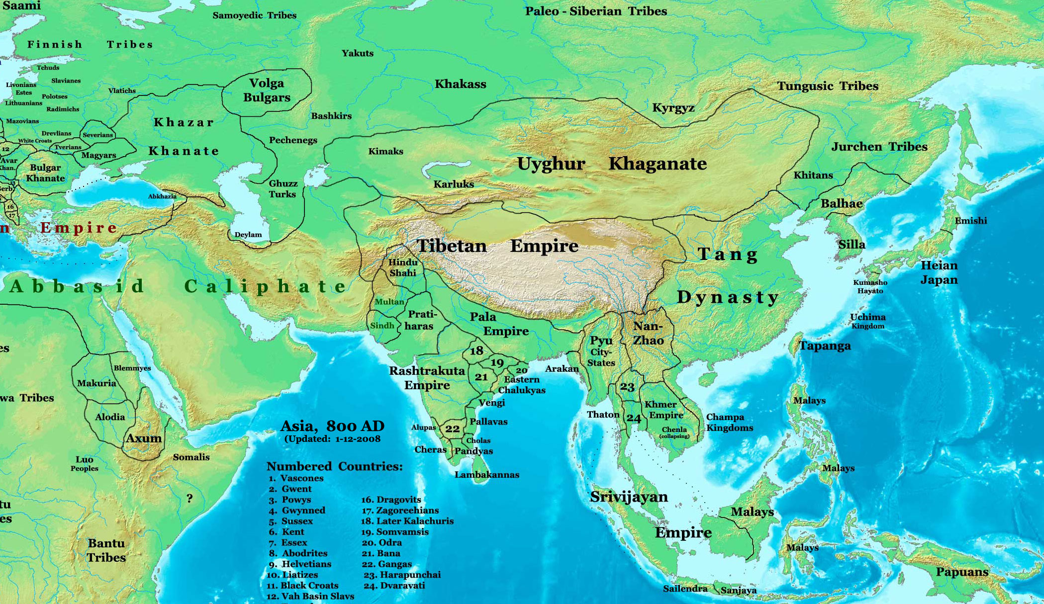
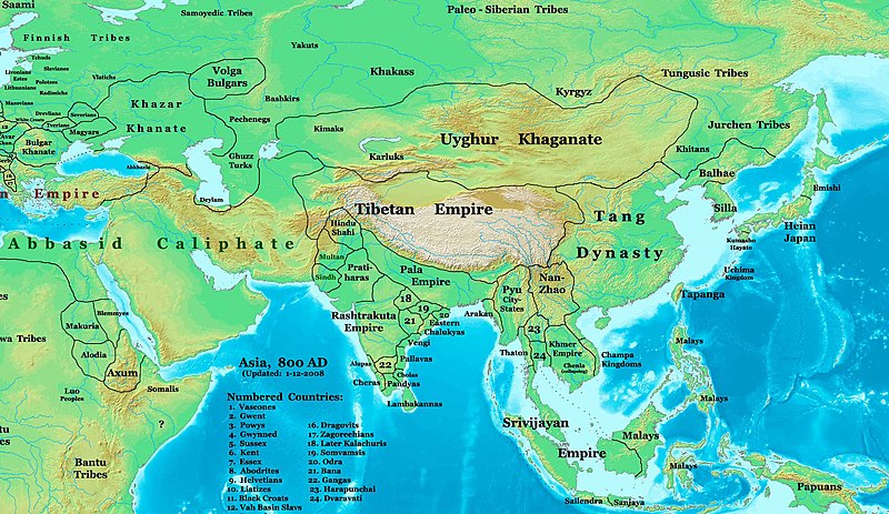
English: This image is a zoomed-in version of Image:East-Hem_800ad.jpg (Eastern Hemisphere in 800 AD).
Author: Thomas A. Lessman. Source URL: http://www.ThomasLessman.com/History/images/East-Hem_800ad.jpg. Image was created by me (Thomas Lessman) based on map of Eastern Hemisphere in 800 AD. Image is free for public and/or educational use. I would appreciate a mention if this image is used elsewhere. If anyone is interested in helping further this work, please contact Thomas Lessman at talessman@yis.us. Other Historical Maps by Thomas Lessman
|
| datum | 22. oktobra 2007 (Original-Hochladedatum); 29. januara 2008 (last version) |
| žórło | Transferred from en.wikipedia to Commons by Vinhtantran using CommonsHelper. |
| awtor | Talessman auf Wikipedija auf jendźelšćina |
| druhe wersije tuteje dataje |
 |


Licencowanje
Talessman auf Wikipedija auf jendźelšćina, awtor tutoho dźěła, wozjewja je z tym pod slědowacymi licencami:

|
Směće tutón dokument pod wuměnjenjemi licency GNU Free Documentation License, wersija 1.2 abo nowša wersija, wozjewjeneje wot załožby Free Software Foundation kopěrować, rozšěrjeć a/abo změnić; njejsu njezměnite wotrězki, njeje žadyn prědni a žadyn zadni wobalkowy tekst. Kopija licency je we wotrězku z titulom GNU Free Documentation License wobsahowana. |
Tuta dataja je pod licencu Creative Commons Attribution 3.0 Unported licencowana
Připokazanje: Talessman auf Wikipedija auf jendźelšćina
- Směš:
- zhromadnje wužiwać – dźěło kopěrować, rozšěrić a dale dać
- změšeć – zo by dźěło přiměrił
- Pod slědowacymi wuměnjenjemi:
- připokazanje – Dyrbiš informacije wo awtorstwje podać, wotkaz k icency přidać a podać, kotre změny sće přewjedł. Móžeće to na přihódne wašnje činić, ale nic tak, zo zaćišć nastawa, zo licencudawar was abo waše wužiwanje podpěruje.
Móžeš licencu swojeje wólby wubrać.
Originalny protokol nahraćow
The original description page was here. All following user names refer to en.wikipedia.
- 2008-01-29 22:50 Talessman 2099×1215×8 (828763 bytes) corrected borders of Tibet and others
- 2007-12-10 23:50 Talessman 2106×1450×8 (911289 bytes) (Correct image uploaded this time; earlier upload was the old version...)
- 2007-12-10 23:48 Talessman 1950×1193×8 (695931 bytes) Uploaded most recently corrected version (as of 12-09-2007)
- 2007-10-31 20:39 Talessman 1950×1193×8 (695931 bytes) Corrected borders of Korea, added info on Far eastern islands
- 2007-10-22 19:15 Talessman 1673×1062×8 (553343 bytes) Author: Thomas A. Lessman. Source URL: http://www.ThomasLessman.com/History/images/East-Hem_800ad.jpg. Image was created by me (Thomas Lessman) based on map of Eastern Hemisphere in 800AD. Image is free for public and/or educational use. I would appreciat
Wersije dataje
Klikń na wěsty čas, zo by wersiju dataje w tutym času zwobraznił.
| Čas | Wobrazowy napohlad | Rozeznaće | Wužiwar | Komentar | |
|---|---|---|---|---|---|
| aktualnje | 23. junija 2008, 06:46 | | 2.099x1.215 (809 kB) | File Upload Bot (Magnus Manske) | {{BotMoveToCommons|en.wikipedia}} {{Information |Description={{en|This image is a zoomed-in version of [http://en.wikipedia.org/wiki/Image:East-Hem_800ad.jpg Eastern Hemisphere in 800 AD]. [[:en:Image:East-Hem_800ad.jpg|thumb|300px|left|Eastern Hemispher |
Datajowe wužiwanje
Njejsu strony, kotrež tutu dataju wužiwaja.
Globalne wužiwanje dataje
Slědowace druhe wikije wužiwaja tutón wobraz:
- Wužiwanje na azb.wikipedia.org
- Wužiwanje na ba.wikipedia.org
- Wužiwanje na bn.wikipedia.org
- Wužiwanje na en.wikipedia.org
- Bangladesh
- West Bengal
- History of Bangladesh
- Jaisalmer
- Portal:Bangladesh
- Gauḍa (city)
- History of Bihar
- Śāntarakṣita
- Pataliputra
- History of Rajasthan
- Horses in East Asian warfare
- Jaisalmer State
- User:Joelton Ivson/Gather lists/24270 – India
- User:Gauravkumar4291/Notes/GS/Cul/Pala Empire
- Horses in ancient and Imperial China
- Wužiwanje na fa.wikipedia.org
- Wužiwanje na fr.wikipedia.org
- Wužiwanje na hi.wikipedia.org
- Wužiwanje na incubator.wikimedia.org
- Wužiwanje na it.wikipedia.org
- Wužiwanje na ka.wikipedia.org
- Wužiwanje na kn.wikipedia.org
- Wužiwanje na ko.wikipedia.org
- Wužiwanje na mai.wikipedia.org
- Wužiwanje na my.wikipedia.org
- Wužiwanje na ne.wikipedia.org
- Wužiwanje na pt.wikipedia.org
- Wužiwanje na ru.wikipedia.org
- Wužiwanje na sl.wikipedia.org
- Wužiwanje na ta.wikipedia.org
- Wužiwanje na te.wikipedia.org
- Wužiwanje na tt.wikipedia.org
- Wužiwanje na uk.wikipedia.org
- Wužiwanje na vi.wikipedia.org