
Dataja:Trebizond1400.png
Za tutu dataju žane wyše rozeznaće njeje.
Trebizond1400.png (635 × 401 pikselow, wulkosć dataje: 107 kB, typ MIME: image/png)
Zjeće
| wopis |
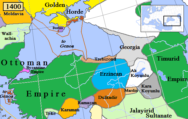
English: Trebizond and surrounding states in Anatolia/Caucasus in AD 1400.
(Partially based on Euratlas map of Europe, 1400, improved since Koza Yayınları Tarih Atlası sf.42; Kanaat Yayınları Tarih Atlası sf.28; Mutafian, Claude & Van Lauwe, Eric: Atlas historique de l'Arménie, Autrement publ., coll. «Atlas/Memoires», Paris 2001, ISBN 2-7467-0100-6 and since the graphic style of [1]) |
| datum | |
| žórło | Swójske dźěło |
| awtor | Gabagool |
![[1]](http://vignette3.wikia.nocookie.net/genealogy/images/c/cf/Trebizond1300.png/revision/latest/thumbnail-down/width/340/height/340?cb=20110516182142)

|
Dieses Bild des Typs Historical map sollte als Vektorgrafik im SVG-Format neu erstellt werden. Vektorformate haben zahlreiche Vorteile; weitere Information unter Commons:Media for cleanup. Wenn dir eine SVG-Version dieses Bildes vorliegt, so lade diese bitte hoch. Nach dem Hochladen der Datei ist diese Vorlage auf der aktuellen Bildbeschreibungsseite durch die Vorlage {{Vector version available}}, oder kürzer {{Vva}}, zu ersetzen. Es ist empfohlen die neue SVG-Datei „Trebizond1400.svg“ zu nennen – dann benötigt die Vorlage vector version available (bzw. vva) keinen Parameter.
|
Licencowanje
Ja, awtor tutoho dźěła, wozjewjam je z tym pod slědowacej licencu:
Tuta dataja je pod licencu Creative Commons Attribution 3.0 Unported licencowana
- Směš:
- zhromadnje wužiwać – dźěło kopěrować, rozšěrić a dale dać
- změšeć – zo by dźěło přiměrił
- Pod slědowacymi wuměnjenjemi:
- připokazanje – Dyrbiš informacije wo awtorstwje podać, wotkaz k icency přidać a podać, kotre změny sće přewjedł. Móžeće to na přihódne wašnje činić, ale nic tak, zo zaćišć nastawa, zo licencudawar was abo waše wužiwanje podpěruje.
Wersije dataje
Klikń na wěsty čas, zo by wersiju dataje w tutym času zwobraznił.
| Čas | Wobrazowy napohlad | Rozeznaće | Wužiwar | Komentar | |
|---|---|---|---|---|---|
| aktualnje | 6. apryla 2018, 13:03 | | 635x401 (107 kB) | Trecătorul răcit | Little changes since ''Koza Yayınları Tarih Atlası'' sf.42; ''Kanaat Yayınları Tarih Atlası'' sf.28; Mutafian, Claude & Van Lauwe, Eric: ''Atlas historique de l'Arménie'', Autrement publ., coll. «Atlas/Memoires», Paris 2001, ISBN 2-7467-0100-6 and since the graphic style of [http://vignette3.wikia.nocookie.net/genealogy/images/c/cf/Trebizond1300.png/revision/latest/thumbnail-down/width/340/height/340?cb=20110516182142] |
| 18. apryla 2009, 00:45 |  | 635x401 (82 kB) | Gabagool | {{Information |Description={{en|1=Trebizond and surrounding states in Anatolia/Caucasus in AD 1400. (Partially based on Euratlas map of Europe, 1400.)}} |Source=Own work by uploader |Author=Gabagool |Date=2009-04-18 |Permission= |other_ |
Datajowe wužiwanje
Dataja so na slědowacych stronach wužiwa:
Globalne wužiwanje dataje
Slědowace druhe wikije wužiwaja tutón wobraz:
- Wužiwanje na ast.wikipedia.org
- Wužiwanje na azb.wikipedia.org
- Wužiwanje na dsb.wikipedia.org
- Wužiwanje na el.wikipedia.org
- Wužiwanje na en.wikipedia.org
- Wužiwanje na et.wikipedia.org
- Wužiwanje na fiu-vro.wikipedia.org
- Wužiwanje na fi.wikipedia.org
- Wužiwanje na fr.wikipedia.org
- Wužiwanje na gl.wikipedia.org
- Wužiwanje na he.wikipedia.org
- Wužiwanje na hu.wikipedia.org
- Komnénosz Teodóra iráni királyné
- Komnénosz Mária trapezunti császári hercegnő (1328–1408)
- Komnénosz Teodóra trapezunti császári hercegnő (?–1435)
- Komnénosz Mária bizánci császárné
- Márta iráni hercegnő
- Caterino Zeno
- Komnénosz Eudokia trapezunti császári hercegnő (IV. Alexiosz lánya)
- Crispo Miklós naxoszi herceg
- Crispo Jolán naxoszi hercegnő
- IV. Ióannész trapezunti császár
- Bagrationi N. trapezunti császárné
- Szeldzsukida Tamar grúz királyné
- Cicisvili Sziti grúz királyné
- II. Dávid trapezunti császár
- Komnénosz N. guriai fejedelemné
- Gabrasz Mária gotthiai hercegnő
- I. Sándor imereti király
- Szeldzsukida Gulsari imereti királyné
- Szeldzsukida Demeter imereti herceg
- Grúz Királyság
- Wužiwanje na id.wikipedia.org
- Wužiwanje na it.wikipedia.org
- Wužiwanje na ka.wikipedia.org
- Wužiwanje na lt.wikipedia.org
- Wužiwanje na lv.wikipedia.org
- Wužiwanje na pt.wikipedia.org
- Wužiwanje na ru.wikipedia.org
- Wužiwanje na sr.wikipedia.org
- Wužiwanje na sv.wikipedia.org
- Wužiwanje na tr.wikipedia.org
- Wužiwanje na uk.wikipedia.org
Globalne wužiwanje tuteje dataje pokazać