
Dataja:SatNordfriesischeInseln.jpg

Wulkosć tutoho přehlada: 296 × 600 pikselow. Druhe rozeznaća: 118 × 240 pikselow | 237 × 480 pikselow | 379 × 768 pikselow | 1.278 × 2.590 pikselow.
Wersija z wyšim rozeznaćom (1.278 × 2.590 pikselow, wulkosć dataje: 1,63 MB, typ MIME: image/jpeg)
Zjeće
| wopis |
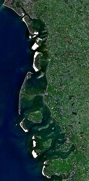
Deutsch: Satellitenaufnahme der Nordfriesischen Inseln (Dänemark/Deutschland) |
| datum | 21. decembra 2005 (Hochladedatum) |
| žórło | Satellite imagery taken from NASA World Wind software (by screenshot) |
| awtor | NASA |
Licencowanje
| Diese Datei ist gemeinfrei (Public Domain), da es sich um einen Screenshot der NASA-Software World Wind handelt, in der ein gemeinfreier Datensatz wie Blue Marble, MODIS, Landsat, SRTM, USGS oder GLOBE verwendet wird.
|
 |
Wersije dataje
Klikń na wěsty čas, zo by wersiju dataje w tutym času zwobraznił.
| Čas | Wobrazowy napohlad | Rozeznaće | Wužiwar | Komentar | |
|---|---|---|---|---|---|
| aktualnje | 21. decembra 2005, 20:37 | | 1.278x2.590 (1,63 MB) | Godewind | * Satellitenaufnahme Nordfriesischen Inseln (Dänemark/Deutschland) * from Nasa World Wind - Free Satellite Image {{PD-USGov}} Category:Satellite photos Category:Satellite images of the islands |
Datajowe wužiwanje
Njejsu strony, kotrež tutu dataju wužiwaja.
Globalne wužiwanje dataje
Slědowace druhe wikije wužiwaja tutón wobraz:
- Wužiwanje na br.wikipedia.org
- Wužiwanje na cs.wikipedia.org
- Wužiwanje na de.wikipedia.org
- Wužiwanje na el.wikipedia.org
- Wužiwanje na es.wikipedia.org
- Wužiwanje na frr.wikipedia.org
- Wužiwanje na hu.wikipedia.org
- Wužiwanje na pl.wikipedia.org
- Wužiwanje na stq.wikipedia.org
- Wužiwanje na zh.wikipedia.org