
Dataja:Karte Deutschland.png
Za tutu dataju žane wyše rozeznaće njeje.
Karte_Deutschland.png (188 × 235 pikselow, wulkosć dataje: 2 kB, typ MIME: image/png)
| wopis |
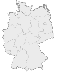
English: Map of Germany with the borders of the 16 federal states.
Deutsch: Karte von Deutschland mit den Grenzen der 16 Bundesländer. |
| datum | Njeznaty datum |
| žórło | OpenGeoDB |
| awtor | NN/OpenGeoDB |
| dowolnosć (dalewužiwanje tuteje dataje) |
GFDL |
This image was generated with OpenGeoDB. The information there is placed in the public domain, images generated from OpenGeoDB are derivative works without passing the threshold of creativity, they are therefore also public domain.
| Diese Datei ist gemeinfrei („public domain“), weil sie nur Allgemeingut enthält und die nötige Schöpfungshöhe nicht erreicht. |

|
File:Germany location map.svg ist eine vektorisierte Version dieses Bildes. Diese sollte an Stelle des Rasterbildes verwendet werden, sofern sie nicht schlechter ist.
File:Karte Deutschland.png → File:Germany location map.svg
Für weitere Informationen siehe Help:SVG. |
 |
Wersije dataje
Klikń na wěsty čas, zo by wersiju dataje w tutym času zwobraznił.
| Čas | Wobrazowy napohlad | Rozeznaće | Wužiwar | Komentar | |
|---|---|---|---|---|---|
| aktualnje | 8. januara 2008, 20:46 | | 188x235 (2 kB) | Evilboy | Reverted to version as of 20:35, 14 March 2007 |
| 14. měrca 2007, 22:35 |  | 188x235 (2 kB) | Tene~commonswiki | Optimised (0) | |
| 9. februara 2007, 13:28 |  | 188x235 (2 kB) | TMg | Contrast slightly improved without loosing precision | |
| 31. januara 2007, 21:04 |  | 188x235 (2 kB) | Leit | Auf eine alte Version zurückgesetzt | |
| 31. januara 2007, 20:17 |  | 188x235 (8 kB) | Der Eberswalder | ||
| 31. januara 2007, 14:29 |  | 188x235 (2 kB) | Rauenstein | Auf eine alte Version zurückgesetzt | |
| 31. januara 2007, 13:04 |  | 188x235 (8 kB) | Der Eberswalder | now white color outside the borders | |
| 31. januara 2007, 12:31 |  | 188x235 (2 kB) | Siebrand | Eerdere versie hersteld | |
| 31. januara 2007, 08:31 |  | 188x235 (9 kB) | Der Eberswalder | better viewable | |
| 27. awgusta 2006, 17:48 |  | 188x235 (2 kB) | TMg | Slightly error corrected version, based on Image:Karte stralsund in deutschland-test.png by de:Benutzer:Rauenstein |
Datajowe wužiwanje
Njejsu strony, kotrež tutu dataju wužiwaja.
Globalne wužiwanje dataje
Slědowace druhe wikije wužiwaja tutón wobraz:
- Wužiwanje na ceb.wikipedia.org
- Wužiwanje na da.wikipedia.org
- Wužiwanje na de.wikipedia.org
- Wužiwanje na nds.wikipedia.org
- Landkreis Emsland
- Landkreis Rodenborg (Wümm)
- Landkreis Stood
- Landkreis Heidkreis
- Landkreis Vechte
- Landkreis Veern
- Kreis Noordfreesland
- Landkreis Cuxhoben
- Landkreis Oosterholt
- Landkreis Horborg
- Landkreis Lümborg
- Kreis Pinnbarg
- Landkreis Ollnborg
- Kreis Steenborg
- Landkreis Weißenburg-Gunzenhausen
- Landkreis Würzburg
- Landkreis Wunsiedel im Fichtelgebirge
- Landkreis Weilheim-Schongau
- Landkreis Unterallgäu
- Landkreis Traunstein
- Landkreis Tirschenreuth
- Landkreis Straubing-Bogen
- Landkreis Starnberg
- Landkreis Schweinfurt
- Landkreis Schwandorf
- Landkreis Rottal-Inn
- Landkreis Roth
- Landkreis Rosenheim
- Landkreis Rhön-Grabfeld
- Landkreis Paane
- Landkreis Wulfenbüttel
- Landkreis Groafschup Bentem
- Landkreis Hameln-Purmunt
- Landkreis Aichach-Friedberg
- Landkreis Altötting
- Landkreis Amberg-Sulzbach
- Landkreis Schaumborg
- Landkreis Ülzen
- Landraodsamt Stemmert
- Wužiwanje na pms.wikipedia.org
Globalne wužiwanje tuteje dataje pokazać