K wobsahej skočić

Dataja:Anglospeak.png

Seiteninhalte werden in anderen Sprachen nicht unterstützt.
Z Wikipedije, swobodneje encyklopedije

Wersija z wyšim rozeznaćom (2.664 × 1.468 pikselow, wulkosć dataje: 115 kB, typ MIME: image/png)

Tuta dataja je z Wikimedia Commons a da so přez druhe projekty wužiwać. Wopisanje na jeje stronje datajoweho wopisanja so deleka pokazuje.


wopis
English:
 
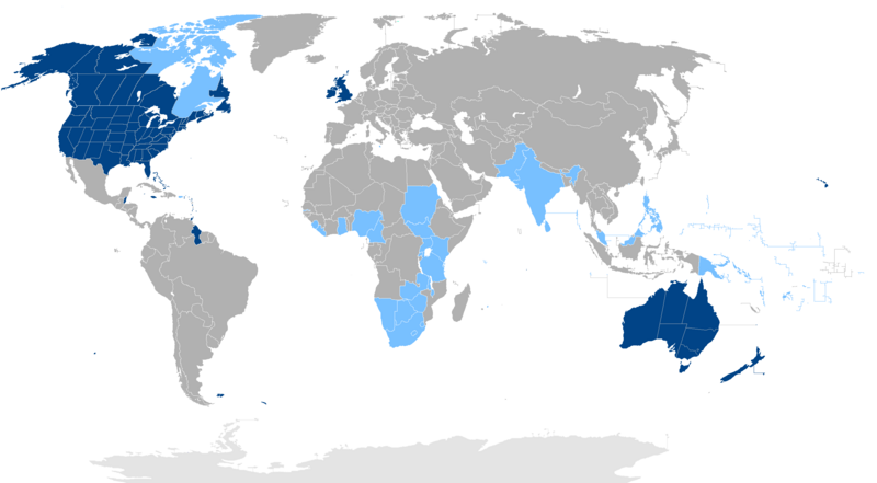
States where English or an English-based creole is the native language of the majority.
 
States where English is an official language, but not the majority language.
datum
žórło Colored by en:User:Iamvered from public domain Wikimedia Commons source
awtor en:User:Iamvered, resized to 800px in width by User:Paunaro
dowolnosć
(dalewužiwanje tuteje dataje)
w:hsb:Cresative Commons
připokazanje
Dataja je pod licencu Creative Commons Namensnennung 2.0 Awstriska licencowana.
Směš:
  • zhromadnje wužiwać – dźěło kopěrować, rozšěrić a dale dać
  • změšeć – zo by dźěło přiměrił
Pod slědowacymi wuměnjenjemi:
  • připokazanje – Dyrbiš informacije wo awtorstwje podać, wotkaz k icency přidać a podać, kotre změny sće přewjedł. Móžeće to na přihódne wašnje činić, ale nic tak, zo zaćišć nastawa, zo licencudawar was abo waše wužiwanje podpěruje.
druhe wersije tuteje dataje
File:Anglospeak (subnational version).svg ist eine vektorisierte Version dieses Bildes. Diese sollte an Stelle des Rasterbildes verwendet werden, sofern sie nicht schlechter ist.


Für weitere Informationen siehe Help:SVG.

In anderen Sprachen
Alemannisch  العربية  беларуская (тарашкевіца)  български  বাংলা  català  нохчийн  čeština  dansk  Deutsch  Ελληνικά  English  British English  Esperanto  español  eesti  euskara  فارسی  suomi  français  Frysk  galego  Alemannisch  עברית  hrvatski  magyar  հայերեն  Bahasa Indonesia  Ido  italiano  日本語  ქართული  한국어  lietuvių  македонски  മലയാളം  Bahasa Melayu  norsk bokmål  Plattdüütsch  Nederlands  norsk nynorsk  norsk  occitan  polski  prūsiskan  português  português do Brasil  română  русский  sicilianu  Scots  slovenčina  slovenščina  српски / srpski  svenska  தமிழ்  ไทย  Türkçe  татарча / tatarça  українська  vèneto  Tiếng Việt  中文  中文(中国大陆)  中文(简体)  中文(繁體)  中文(马来西亚)  中文(新加坡)  中文(臺灣)  中文(臺灣)  +/−
Neue Vektorgrafik

File:English language distribution.svg ist eine vektorisierte Version dieses Bildes. Diese sollte an Stelle des Rasterbildes verwendet werden, sofern sie nicht schlechter ist.


Für weitere Informationen siehe Help:SVG.

In anderen Sprachen
Alemannisch  العربية  беларуская (тарашкевіца)  български  বাংলা  català  нохчийн  čeština  dansk  Deutsch  Ελληνικά  English  British English  Esperanto  español  eesti  euskara  فارسی  suomi  français  Frysk  galego  Alemannisch  עברית  hrvatski  magyar  հայերեն  Bahasa Indonesia  Ido  italiano  日本語  ქართული  한국어  lietuvių  македонски  മലയാളം  Bahasa Melayu  norsk bokmål  Plattdüütsch  Nederlands  norsk nynorsk  norsk  occitan  polski  prūsiskan  português  português do Brasil  română  русский  sicilianu  Scots  slovenčina  slovenščina  српски / srpski  svenska  தமிழ்  ไทย  Türkçe  татарча / tatarça  українська  vèneto  Tiếng Việt  中文  中文(中国大陆)  中文(简体)  中文(繁體)  中文(马来西亚)  中文(新加坡)  中文(臺灣)  中文(臺灣)  +/−
Neue Vektorgrafik

This 800-pixel-in width sized image is used for an image map in the article en:English language, first time in version number 173767913 on 2007-11-25, and also de:Englische Sprache, first time in version number 39378159 on 2007-11-25.

It is very important to keep this 800 pixel version, for the coordinates refer to 800 pixels, and will not work using another version of this image.

This image map could be easily transformed into any other desired language. Just change the wiki links. Here is the source:

{{legend|#004288|States where English is the national language or the native language of the majority.}}
{{legend|#3f48cc|States where a spectrum of English and [[:en:English-based creole languages|English-based creole languages]] form the national language.}}
{{legend|#79c1ff|States where English is an official language, but not the majority language.}}
''Click on a coloured region to get related article:''
{| cellpadding="2" cellspacing="2" border="0" align="center"
| valign="top" |
<imagemap>
Image:Anglospeak(800px).png|800px|English speaking countries
poly 311 122 345 115 369 124 413 126 415 118 393 118 397 107 404 98 397 55 410 27 359 29 339 55 345 76 326 84 314 96 308 109 [[European Union]]
poly 89 33 62 54 67 58 70 62 70 66 66 71 64 78 62 75 61 85 69 86 72 84 133 85 146 88 149 94 153 94 152 97 150 103 174 95 172 91 167 89 167 81 166 74 169 66 156 59 165 50 173 50 182 49 190 48 200 47 206 53 214 54 226 39 210 24 229 16 253 3 192 8 127 22 [[Canada]]
poly 196 48 177 56 168 73 168 81 167 90 173 94 184 90 202 89 217 78 200 75 200 72 206 69 209 59 [[Quebec]]
poly 211 55 206 70 198 69 199 75 204 77 215 78 214 80 207 87 187 90 187 96 190 98 224 87 224 68 [[Canada]]
poly 89 31 58 58 40 60 6 71 6 62 32 36 58 30 87 29 [[Alaska]]
circle 211 353 15 [[Falkland islands]]
circle 142 173 13 [[Jamaica]]
rect 109 159 126 180 [[Belize]]
poly 328 73 314 70 310 81 323 83 [[Ireland]]
rect 315 64 326 73 [[Northern Ireland]]
poly 326 58 326 68 328 72 325 84 336 83 345 76 337 59 [[Great Britain]]
poly 402 288 395 294 407 308 412 297 [[Lesotho]]
poly 406 308 394 295 402 287 414 298 419 286 407 288 407 284 410 284 409 277 405 275 393 284 390 282 385 287 382 282 378 291 371 289 374 307 403 310 [[South Africa]]
poly 412 282 407 286 407 289 411 289 418 289 419 277 [[Swaziland]]
poly 452 247 438 258 436 284 450 290 460 249 [[Madagascar]]
poly 299 202 311 192 306 187 293 190 [[Sierra Leone]]
poly 299 204 310 194 318 199 312 211 [[Ivory coast]]
rect 324 183 338 210 [[Ghana]]
poly 348 259 385 262 379 290 354 292 [[Namibia]]
poly 397 264 386 263 381 279 384 287 388 280 392 283 403 276 [[Botswana]]
poly 406 258 401 264 404 274 411 274 415 266 415 259 [[Zimbabwe]]
poly 389 263 402 264 414 252 417 242 409 238 402 240 402 246 390 243 385 252 [[Zambia]]
poly 414 238 413 254 420 262 426 255 422 244 [[Malawi]]
poly 429 227 416 219 409 219 405 228 407 237 418 241 424 246 442 246 441 227 [[Tanzania]]
poly 399 215 410 221 404 228 395 224 [[Rwanda]]
rect 644 245 421 220 [[Uganda]]
poly 421 200 418 213 418 218 429 226 440 220 439 204 [[Kenya]]
rect 386 152 425 202 [[Sudan]]
poly 342 176 338 199 337 208 351 210 355 203 357 195 363 196 373 182 368 176 [[Nigeria]]
poly 371 188 358 196 354 211 362 219 376 215 378 194 [[Cameroon]]
poly 515 121 505 123 511 130 504 139 502 143 504 148 492 163 475 153 470 132 499 109 508 108 516 114 [[Pakistan]]
poly 540 133 544 140 554 142 560 135 569 140 558 160 537 170 528 192 519 195 505 169 499 156 503 146 501 142 510 129 507 123 520 114 [[India]]
poly 543 133 544 142 551 145 557 137 555 129 546 130 [[Bhutan]]
poly 665 323 636 312 582 316 593 256 651 244 689 245 710 285 700 317 [[Australia]]
rect 649 321 683 341 [[Tasmania]]
poly 729 302 694 328 695 352 754 347 770 301 [[New Zealand]]
rect 682 213 737 254 [[Papua New Guinea]]
poly 759 238 759 281 781 279 791 240 [[Fiji]]
circle 511 202 12 [[Maldives]]
rect 615 163 657 207 [[Philippines]]
circle 476 274 21 [[Mauritius]]
poly 143 138 139 151 159 162 168 153 159 140 [[The Bahamas]]
poly 69 85 135 86 154 93 156 100 190 87 194 92 181 99 157 125 143 133 142 147 139 149 127 139 100 149 38 122 55 87 [[United States]]
circle 320 261 20 [[Saint Helena]]
rect 176 193 202 224 [[Guyana]]
rect 164 156 175 178 [[Puerto Rico]]
rect 175 156 198 193 [[Antilles|Windward Islands and Leeward Islands]]
circle 187 129 20 [[Bermuda]]
desc none
</imagemap>
|}

Here is what this looks like:

 
States where English is the national language or the native language of the majority.
 
States where English is an official language, but not the majority language.

Click on a coloured region to get related article:

English speaking countriesWindward Islands and Leeward Islands
English speaking countries

Have fun using this image map! With kind regards.

Legend translations:

中文:
 
英语是官方语言及主要第一语言的国家
 
英语是官方语言但非主要第一语言的国家
Español:
 
Países donde el inglés es el idioma nacional o el idioma nativo de la mayoría.
 
Países donde el inglés es un idioma oficial, pero no la lengua de la mayoría.
العربية:
 
.البلدان التي تكون فيها اللغة الإنجليزية هي اللغة الوطنية أو اللغة الأم للأغلبية
 
.البلدان التي تكون فيها اللغة الإنجليزية هي اللغة الرسمية ولكن ليس لغة الأغلبية
हिन्दी:
 
देश जहाँ अंग्रेजी राष्ट्रीय भाषा या बहुमत की मूल भाषा है.
 
देश जहाँ अंग्रेजी एक अधिकारी लेकिन बहुमत भाषा नहीं भाषा है.
বাংলা:
 
দেশ যেখানে ইংরেজি জাতীয় ভাষা বা অধিকাংশ স্থানীয় ভাষা.
 
দেশ যেখানে ইংরেজি প্রাতিষ্ঠানিক ভাষা, অধিকাংশ ভাষা কিন্তু না.
Português:
 
Países onde o Inglês é a língua nacional ou a língua nativa da maioria.
 
Países onde o Inglês é uma língua oficial, mas não a língua majoritária.
Русский:
 
Страны, где английский язык является национальным языком или родным языком большинства.
 
Страны, где английский язык является официальным языком, но не на языке большинства.
日本語:
 
英語が公用語または大部分のネイティブ言語である国。
 
英語が公用語ではなく、多数派言語である国。
Deutsch:
 
Länder, in denen Englisch die Landessprache oder die Sprache der Mehrheit ist.
 
Länder, in denen Englisch Amtssprache ist, aber nicht die Sprache der Mehrheit.
Français :
 
Les pays où l'anglais est la langue nationale ou la langue maternelle de la majorité.
 
Les pays où l'anglais est une langue officielle, mais pas la langue majoritaire.
తెలుగు:
 
ఆంగ్ల జాతీయ భాష లేదా మెజారిటీ మాతృ భాషగా ఉంది దేశాలలో.
 
ఆంగ్ల ఒక అధికారిక భాష దేశాలలో, కానీ మెజారిటీ భాష.
தமிழ்:
 
ஆங்கிலம் தேசிய மொழி அல்லது பெரும்பான்மை மொழி நாடுகளில்.
 
ஆங்கிலம் ஒரு ஆட்சி மொழியாக நாடுகளில், ஆனால் பெரும்பான்மை மொழி.
Tiếng Việt:
 
Những nước mà tiếng Anh là ngôn ngữ chính hoặc ngôn ngữ bản địa của đa số.
 
Những nước mà tiếng Anh là ngôn ngữ chính thức, nhưng không phải là ngôn ngữ đa số.
한국어:
 
영어가 국어이거나 다수의 모국어인 국가입니다.
 
영어가 공용어이지만 다수 언어는 아닌 국가입니다.
Italiano:
 
Paesi dove l'inglese è la lingua nazionale o la lingua madre della maggioranza.
 
Paesi dove l'inglese è una lingua ufficiale, ma non la lingua della maggioranza.
اردو:
 
ممالک جہاں انگریزی قومی زبان ہے یا اکثریت کی مادری زبان ہے.
 
ممالک جہاں انگریزی کسی سرکاری زبان مگر نہیں اکثریت کی زبان ہے.
Türkçe:
 
İngilizce resmi dil veya çoğunluğunun ana dili olduğu ülkelerde.
 
İngilizce resmi dil olduğu ülkeler, ancak çoğunluk dili.
ગુજરાતી:
 
એવા દેશો કે જ્યાં ઇંગલિશ રાષ્ટ્રીય ભાષા કે મોટા ભાગના મૂળ ભાષા છે.
 
એવા દેશો કે જ્યાં ઇંગલિશ સત્તાવાર ભાષા છે, મોટા ભાગના ભાષા નથી, પરંતુ.
Polski:
 
Kraje, w których angielski jest językiem narodowym lub języka ojczystego większości.
 
Kraje, w których angielski jest językiem urzędowym, ale nie języka większości.
Bahasa Melayu:
 
Negara-negara di mana Bahasa Inggeris adalah bahasa kebangsaan atau bahasa ibunda majoriti.
 
Negara-negara di mana Bahasa Inggeris merupakan bahasa rasmi tetapi tidak bahasa majoriti.
Filipino:
 
Bansa kung saan Ingles ay ang pambansang wika o ang katutubong wika ng karamihan.
 
Bansa kung saan Ingles ay ang opisyal na wika ngunit hindi sa karamihan wika.
Українська:
 
Країни, де англійська мова є національною мовою або рідною мовою більшості.
 
Країни, де англійська мова є офіційною мовою, але не мовою більшості.
ಕನ್ನಡ:
 
ಇಂಗ್ಲೀಷ್ ರಾಷ್ಟ್ರೀಯ ಭಾಷೆ ಅಥವಾ ಬಹುತೇಕ ಸ್ಥಳೀಯ ಭಾಷೆ ದೇಶಗಳು.
 
ಇಂಗ್ಲೀಷ್ ಅಧಿಕೃತ ಭಾಷೆಯಾಗಿದೆ ದೇಶಗಳು, ಆದರೆ ಬಹುತೇಕ ಭಾಷೆ.
فارسی:
 
.کشورهایی که انگلیسی زبان ملی یا زبان مادری اکثریت
 
.کشورهایی که انگلیسی زبان رسمی است، اما به زبان اکثریت است
Nederlands:
 
Landen waar Engels de nationale taal of de moedertaal van de meerderheid is.
 
Landen waar Engels een officiële taal, maar niet de meerderheidstaal is.
Ελληνικά:
 
Οι χώρες όπου τα αγγλικά είναι η εθνική γλώσσα ή τη μητρική γλώσσα της πλειοψηφίας.
 
Οι χώρες όπου τα αγγλικά είναι επίσημη γλώσσα, αλλά δεν είναι η γλώσσα πλειοψηφία.
Euskara:
 
Hizkuntza nazionala edo gehiengoaren ama-hizkuntza.
 
Hizkuntza ofiziala baina ez gehien erabiliena.
Annotations
InfoField
This image is annotated: View the annotations at Commons

Krótkowopisy

Dodaj jednolinkowy wopis tuteje dataje.
map of where English/Creole is official or the majority language

MIME-Typ němčina

image/png

Prüfsumme němčina

418d6ebe8bda310a6dfc8a84c410875dbf219b13

Bestimmungsmethode němčina: SHA-1 němčina

Dateigröße němčina

118.110 Byte

1.468 Pixel

2.664 Pixel

Wersije dataje

Klikń na wěsty čas, zo by wersiju dataje w tutym času zwobraznił.

(najnowšu | najstaršu) (nowšich 10) () (10 | 20 | 50 | 100 | 250 | 500) pokazać
ČasWobrazowy napohladRozeznaćeWužiwarKomentar
aktualnje1. septembra 2020, 16:42Wobrazowy napohlad za wersiju wot 1. septembra 2020, 16:422.664x1.468 (115 kB)Avocado JAdded a more detailed map. In Sri Lanka, 23.8% speak English and 5% primary language.
16. awgusta 2019, 21:08Wobrazowy napohlad za wersiju wot 16. awgusta 2019, 21:082.664x1.468 (115 kB)KwamikagamiReverted to version as of 21:20, 23 July 2019 (UTC) 2½% in Liberia is not a majority
9. awgusta 2019, 11:10Wobrazowy napohlad za wersiju wot 9. awgusta 2019, 11:102.664x1.468 (115 kB)Nicholas05Cleanup!
6. awgusta 2019, 09:24Wobrazowy napohlad za wersiju wot 6. awgusta 2019, 09:242.664x1.468 (115 kB)Nicholas05Changed Sierra Leone and Libera as a majority native language.
23. julija 2019, 22:20Wobrazowy napohlad za wersiju wot 23. julija 2019, 22:202.664x1.468 (115 kB)Kwamikagamimade Antarctica lighter grey, since we're not counting it. Marianas light blue, as English is a minority language. Add Seychelles and Mauritius, as English is de facto co-official as it is in Malaysia, which is light blue.
22. apryla 2019, 23:25Wobrazowy napohlad za wersiju wot 22. apryla 2019, 23:252.664x1.468 (73 kB)MottezenRemoved Taiwan, French Polynesia, and Wallis and Futuna
9. februara 2019, 22:04Wobrazowy napohlad za wersiju wot 9. februara 2019, 22:042.664x1.468 (115 kB)RainbowSilver2ndBackupAdded Cameroon
9. februara 2019, 22:02Wobrazowy napohlad za wersiju wot 9. februara 2019, 22:022.664x1.468 (115 kB)RainbowSilver2ndBackupAdded Sudan
9. decembra 2018, 03:31Wobrazowy napohlad za wersiju wot 9. decembra 2018, 03:312.664x1.468 (114 kB)KoavfROC per <ref name="roc">{{Cite web |url=https://www.hongkongfp.com/2018/08/31/taiwan-make-english-official-language-next-year-says-official/ |title=Taiwan to make English an official language next year, says official |last=Creery |first=Jennifer |date=31 August 2018 |accessdate=8 December 2018 |work=Hong Kong Free Press}}</ref>
26. januara 2018, 14:35Wobrazowy napohlad za wersiju wot 26. januara 2018, 14:352.664x1.468 (124 kB)MaphobbyistAdjusted coloring of the Caribbean states.
(najnowšu | najstaršu) (nowšich 10) () (10 | 20 | 50 | 100 | 250 | 500) pokazać

Njejsu strony, kotrež tutu dataju wužiwaja.

Globalne wužiwanje dataje

Slědowace druhe wikije wužiwaja tutón wobraz:

Metadaty

Z Wikipedije, swobodneje encyklopedije