
Dataja:Aras River, Turkey-Armenia-Iran Border Region.JPG

Wersija z wyšim rozeznaćom (4.288 × 2.848 pikselow, wulkosć dataje: 13,14 MB, typ MIME: image/jpeg)
Zjeće
| wopis |
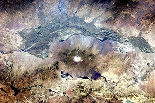
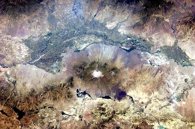
English: This astronaut photograph, taken from the International Space Station, highlights a segment of the international border between Armenia and Turkey. The Aras River separates the two countries, with Armenia to the north-north-east and Turkey to the south-south-west. Extensive green agricultural fields are common on both sides of the river (upper part of image), as well as a number of gray-to-tan urban areas including Yerevan (image top, slightly left of centre) and Artashat and Armavir in Armenia, and Iğdır in Turkey. While there have been efforts to normalize diplomatic relations between the two countries in recent years, the Armenia-Turkey border remains officially closed.
The dominant geographic feature in the region is Mt. Ararat, also known as Agri Dagi. The peak of Ararat, a large stratovolcano that last erupted in 1840 according to historical records, is located approximately 40 kilometres to the south of the Armenia-Turkey border. A lower peak to the east, known as Lesser or Little Ararat, is also volcanic in origin. Dark gray lava flows to the south of Mt. Ararat are located near the Turkish border with Iran. While this border is also closed along much of its length, official crossing points allow relatively easy travel between the two countries. The white, glacier-clad peak of Mt. Ararat is evident at image centre; dark green areas on the lower slopes indicate where vegetation cover is abundant. A large lake, Balik Golu or Fish Lake, is visible to the west (image lower left). |
| datum | |
| žórło | NASA Earth Observatory |
| awtor | ISS Expedition 28 crew |
| Pozicija kamery | | Tónle a dalše wobrazy pola: OpenStreetMap |
|---|
Diese Mediendatei wurde vom Johnson Space Center der US-amerikanischen National Aeronautics and Space Administration (NASA) unter der Datei-ID ISS028-E-15023 kategorisiert. Diese Markierung zeigt nicht den Urheberrechtsstatus des zugehörigen Werks an. Es ist in jedem Falle zusätzlich eine normale Lizenzvorlage erforderlich. Siehe Commons:Lizenzen für weitere Informationen. Sprachen:
|
Image acquired with a Nikon D2Xs digital camera using a 65 mm lens, and is provided by the ISS Crew Earth Observations experiment and Image Science & Analysis Laboratory, Johnson Space Center.
Licencowanje
| Diese Datei ist gemeinfrei (public domain), da sie von der NASA erstellt worden ist. Die NASA-Urheberrechtsrichtlinie besagt, dass „NASA-Material nicht durch Urheberrecht geschützt ist, wenn es nicht anders angegeben ist“. (NASA-Urheberrechtsrichtlinie-Seite oder JPL Image Use Policy). | ||
 |
Warnung:
|
| Bildnotizen | Diese Datei ist annotiert: Betrachte diese auf Commons. |
Wersije dataje
Klikń na wěsty čas, zo by wersiju dataje w tutym času zwobraznił.
| Čas | Wobrazowy napohlad | Rozeznaće | Wužiwar | Komentar | |
|---|---|---|---|---|---|
| aktualnje | 25. julija 2011, 20:37 | | 4.288x2.848 (13,14 MB) | Originalwana | {{Information |Description ={{en|1=This astronaut photograph, taken from the International Space Station, highlights a segment of the international border between Armenia and Turkey. The Aras River separates the two countries, with Armenia |
Datajowe wužiwanje
Dataja so na slědowacych stronach wužiwa:
Globalne wužiwanje dataje
Slědowace druhe wikije wužiwaja tutón wobraz:
- Wužiwanje na af.wikipedia.org
- Wužiwanje na ar.wikipedia.org
- Wužiwanje na ast.wikipedia.org
- Wužiwanje na avk.wikipedia.org
- Wužiwanje na bn.wikipedia.org
- Wužiwanje na ca.wikipedia.org
- Wužiwanje na en.wikipedia.org
- Wužiwanje na es.wikipedia.org
- Wužiwanje na fa.wikipedia.org
- Wužiwanje na fi.wikipedia.org
- Wužiwanje na gl.wikipedia.org
- Wužiwanje na hy.wikipedia.org
- Wužiwanje na hyw.wikipedia.org
- Wužiwanje na it.wikipedia.org
- Wužiwanje na ja.wikipedia.org
- Wužiwanje na ka.wikipedia.org
- Wužiwanje na ku.wikipedia.org
- Wužiwanje na ml.wikipedia.org
- Wužiwanje na pt.wikipedia.org
- Wužiwanje na ro.wikipedia.org
- Wužiwanje na ru.wikipedia.org
- Wužiwanje na sk.wikipedia.org
- Wužiwanje na sl.wikipedia.org
- Wužiwanje na sv.wikipedia.org
- Wužiwanje na tr.wikipedia.org
- Wužiwanje na ur.wikipedia.org
- Wužiwanje na uz.wikipedia.org