
Dataja:Rzeczpospolita.png

Wulkosć tutoho přehlada: 765 × 600 pikselow. Druhe rozeznaća: 306 × 240 pikselow | 612 × 480 pikselow | 980 × 768 pikselow | 1.280 × 1.004 pikselow | 2.000 × 1.568 pikselow.
Wersija z wyšim rozeznaćom (2.000 × 1.568 pikselow, wulkosć dataje: 332 kB, typ MIME: image/png)
Zjeće
| wopis |
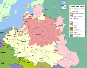
English: Commonwealth of Both Nations at the peak of its strength. The areas marked with light pink were lost to:
|
| datum | |
| žórło | Swójske dźěło |
| awtor | Halibutt |
| dowolnosć (dalewužiwanje tuteje dataje) |
GFDL, see below |
| druhe wersije tuteje dataje |
|

|
Dieses Bild des Typs Historical map sollte als Vektorgrafik im SVG-Format neu erstellt werden. Vektorformate haben zahlreiche Vorteile; weitere Information unter Commons:Media for cleanup. Wenn dir eine SVG-Version dieses Bildes vorliegt, so lade diese bitte hoch. Nach dem Hochladen der Datei ist diese Vorlage auf der aktuellen Bildbeschreibungsseite durch die Vorlage {{Vector version available}}, oder kürzer {{Vva}}, zu ersetzen. Es ist empfohlen die neue SVG-Datei „Rzeczpospolita.svg“ zu nennen – dann benötigt die Vorlage vector version available (bzw. vva) keinen Parameter.
|
Licencowanje
Since the legal status of the above comment has been questioned, I hereby grant anyone the right to treat it as either a standard copyright notice, invariant section, legal statement, legal advice, friendly suggestion or a mere comment, depending on his or hers own choice. |
|

History of Poland
The following is a list of maps created by Halibutt and uploaded to commons, as well as their present and projected derivatives.
| Parent Image | Image | Description | |||||||||||
|---|---|---|---|---|---|---|---|---|---|---|---|---|---|
| Maps by Halibutt | |||||||||||||
| Image:Rzeczpospolita.png | Image:Rzeczpospolita.png | The Republic in 17th and 18th century | |||||||||||
| Image:Rzeczpospolita 1600.png | The Republic after the Treaty of Dywilino | ||||||||||||
| Image:Rzeczpospolita voivodships.png | Voivodships of The Republic | ||||||||||||
| Image:Rzeczpospolita_Potop.png | The Republic during The Deluge and Chmielnicki Uprising, with major battles of the era marked | ||||||||||||
| Magnates and their lands and domains | |||||||||||||
| 1st • 2nd • 3rd | Partitions of Poland | ||||||||||||
| War of the constitution | |||||||||||||
| Image:Rzeczpospolita.xcf | SOURCE FILE - GIMP format | ||||||||||||
| Image:Poland 1939.png | Image:Poland 1939.png | Poland in 1939 | |||||||||||
| Image:Dywizje wrzesien 1.png | Order of Battle on September 1st, during the Polish Defence War of 1939 | ||||||||||||
| Image:Poland 1939.xcf | SOURCE FILE - GIMP format | ||||||||||||
| Image:Polska kontur bialy.png | Image:Polska kontur bialy.png | Contour map of Poland AD 1999, for use with various locator maps | |||||||||||
| Image:Rzeczpospolita 1923.png | Image:Rzeczpospolita 1923.png | Map of Poland 1918-1939, currently under development | |||||||||||
| Image:PBW March 1919.png | Polish-Bolshevik War - fronts in March of 1919 | ||||||||||||
| Image:PBW December 1919.png | Polish-Bolshevik War - fronts in December of 1919 | ||||||||||||
| Image:PBW June 1920.png | Polish-Bolshevik War - fronts in July of 1920 | ||||||||||||
| Image:PBW August 1920.png | Polish-Bolshevik War - fronts in August of 1920 | ||||||||||||
| Polish Defence War of 1939 | |||||||||||||
| Polish areas annexed by Germany, Lithuania, Slovakia and the Soviet Union | |||||||||||||
| German concentration camps in Poland | |||||||||||||
| Curzon line | |||||||||||||
| Major battles of the Polish-Bolshevik War | |||||||||||||
| names • no names | Polish/Czechoslovak/Lithuanian/German/Ukrainian claims in 1920's | ||||||||||||
| Image:Rzeczpospolita Central Lithuania.png | Central Lithuania | ||||||||||||
| Image:Rzeczpospolita Lithuania claims.png | Central Lithuania as compared with other Lithuanian claims | ||||||||||||
| Image:Rzeczpospolita 1789-1920.png | Post-1922 borders compared with the territory of Poland before the partitions | ||||||||||||
| Warsaw Uprising and the Operation Tempest | |||||||||||||
| Poland partitioned between the Soviets and the Germans | |||||||||||||
| Image:Rzeczpospolita 1939 Polish divisions.png | Polish divisions on September 1, 1939 | ||||||||||||
| Home Army inspectorates | |||||||||||||
| Image:Rzeczpospolita 1922.xcf | SOURCE FILE - GIMP format | ||||||||||||
| Image:Rzeczpospolita 1937.svg | Vector version!!!! | layered version available on request | |||||||||||

|
Dieses Bild (oder alle Bilder in dieser Kategorie) benutzt eingesetzte Bezeichnungen oder eine fest angefügte Legende in einer bestimmten Schrift oder Sprache und sollte möglichst in eine sprachneutrale Form gebracht werden. Dies würde es ermöglichen die Datei in allen Wikimedia Projekten und wichtiger noch, in allen Wikimedia Sprachen, zu verwenden.
|
Wersije dataje
Klikń na wěsty čas, zo by wersiju dataje w tutym času zwobraznił.
| Čas | Wobrazowy napohlad | Rozeznaće | Wužiwar | Komentar | |
|---|---|---|---|---|---|
| aktualnje | 6. meje 2016, 16:37 | | 2.000x1.568 (332 kB) | Julieta39 | Cosmetic changes: see sources in the discussion page of today. |
| 8. decembra 2009, 12:40 |  | 2.000x1.568 (221 kB) | Tryphon | Removed watermark. | |
| 13. decembra 2004, 21:34 |  | 2.000x1.568 (304 kB) | Halibutt | Ok, final version at last (unless you have some more comments or suggestions) | |
| 10. decembra 2004, 09:47 |  | 2.000x1.568 (297 kB) | Halibutt | final version? | |
| 10. decembra 2004, 03:36 |  | 2.000x1.568 (193 kB) | Halibutt | new update | |
| 8. decembra 2004, 05:23 |  | 2.000x1.568 (141 kB) | Halibutt | Commonwealth of Both Nations at the peak of its strength<br>Beta version of a map by Halibutt<br>{{User:Halibutt/GFDL}} |
Datajowe wužiwanje
Dataja so na slědowacych stronach wužiwa:
Globalne wužiwanje dataje
Slědowace druhe wikije wužiwaja tutón wobraz:
- Wužiwanje na ar.wikipedia.org
- Wužiwanje na arz.wikipedia.org
- Wužiwanje na azb.wikipedia.org
- Wužiwanje na bg.wikipedia.org
- Wužiwanje na br.wikipedia.org
- Wužiwanje na ca.wikipedia.org
- Wužiwanje na da.wikipedia.org
- Wužiwanje na de.wikipedia.org
- Wužiwanje na de.wikibooks.org
- Wužiwanje na en.wikipedia.org
- Wužiwanje na eo.wikipedia.org
- Wužiwanje na et.wikipedia.org
- Wužiwanje na fi.wikipedia.org
- Wužiwanje na fr.wikipedia.org
- Wužiwanje na gl.wikipedia.org
- Wužiwanje na hr.wikipedia.org
- Wužiwanje na hu.wikipedia.org
- Wužiwanje na id.wikipedia.org
- Wužiwanje na it.wikipedia.org
- Wužiwanje na ja.wikipedia.org
Globalne wužiwanje tuteje dataje pokazać