
Dataja:Palouse hills northeast of Walla Walla.jpg

Wulkosć tutoho přehlada: 800 × 451 pikselow. Druhe rozeznaća: 320 × 180 pikselow | 640 × 361 pikselow | 1.118 × 630 pikselow.
Wersija z wyšim rozeznaćom (1.118 × 630 pikselow, wulkosć dataje: 589 kB, typ MIME: image/jpeg)
| wopis |
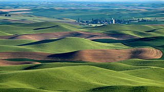
We were hearing a sound like a plane and couldn't figure out where the plane was. Finally one of us spotted a yellow plane flying in the area of the grain elevator! Amazing. Steptoe Butte is the perfect high point in the Palouse Hills to catch the shadow and light play on the hills of the area at sunset and sunrise. This is a morning capture. During one of the ice ages (about 15,000 years ago) Clark Fork River (Montana) was dammed by ice, forming Missoula Lake, the top of which was about 2,000 feet in elevation. About every 2 to 60 years there was thermal erosion of the ice dam and it would collapse and let a flood go through for about 3 days -- whatever time it took to drain Missoula Lake. Many layers of silt left by multiple Missoula floods were topped by loess (dirt blown on top) which made for great rolling hills of farmlands. |
| datum | |
| žórło | Hills, grain elevator, and little yellow plane (really) |
| awtor | Lynn Suckow from Walla Walla, WA, USA |
Licencowanje
Tuta dataja je pod licencu Creative Commons Attribution-Share Alike 2.0 Generic licencowana
- Směš:
- zhromadnje wužiwać – dźěło kopěrować, rozšěrić a dale dać
- změšeć – zo by dźěło přiměrił
- Pod slědowacymi wuměnjenjemi:
- připokazanje – Dyrbiš informacije wo awtorstwje podać, wotkaz k icency přidać a podać, kotre změny sće přewjedł. Móžeće to na přihódne wašnje činić, ale nic tak, zo zaćišć nastawa, zo licencudawar was abo waše wužiwanje podpěruje.
- dźělić – Jeli tute dźěło měnješ, přetworjuješ abo na njo natwarješ, móžeš hotowe dźěło jenož pod samsnej abo podobnej licencu kaž tuta rozšěrić.
| Dieses Bild wurde ursprünglich auf Flickr veröffentlicht und am January 13, 2009 vom Administrator oder vertrauenswürdigen Benutzer File Upload Bot (Magnus Manske) überprüft. Die Überprüfung ergab, dass das Bild zum Zeitpunkt der Überprüfung auf Flickr mit der oben genannten Lizenz markiert war. |
Wersije dataje
Klikń na wěsty čas, zo by wersiju dataje w tutym času zwobraznił.
| Čas | Wobrazowy napohlad | Rozeznaće | Wužiwar | Komentar | |
|---|---|---|---|---|---|
| aktualnje | 13. januara 2009, 17:03 | | 1.118x630 (589 kB) | File Upload Bot (Magnus Manske) | {{Information |Description= We were hearing a sound like a plane and couldn't figure out where the plane was. Finally one of us spotted a yellow plane flying in the area of the grain elevator! Amazing. Steptoe Butte is the perfect high point in the Pa |
Datajowe wužiwanje
Dataja so na slědowacych stronach wužiwa:
Globalne wužiwanje dataje
Slědowace druhe wikije wužiwaja tutón wobraz:
- Wužiwanje na ar.wikipedia.org
- Wužiwanje na de.wikipedia.org
- Wužiwanje na en.wikipedia.org
- Wužiwanje na en.wikivoyage.org
- Wužiwanje na es.wikipedia.org
- Wužiwanje na ga.wikipedia.org
- Wužiwanje na it.wikipedia.org
- Wužiwanje na it.wikibooks.org
- Wužiwanje na it.wikiversity.org
- Wužiwanje na ja.wikipedia.org
- Wužiwanje na nl.wikipedia.org
- Wužiwanje na ru.wikipedia.org
- Wužiwanje na simple.wikipedia.org
- Wužiwanje na tr.wikipedia.org
- Wužiwanje na uk.wikipedia.org
- Wužiwanje na vi.wikipedia.org