
Dataja:Narva basin map.svg

Größe der PNG-Vorschau dieser SVG-Datei: 423 × 599 pikselow. Druhe rozeznaća: 169 × 240 pikselow | 339 × 480 pikselow | 542 × 768 pikselow | 722 × 1.024 pikselow | 1.445 × 2.048 pikselow | 743 × 1.053 pikselow.
Wersija z wyšim rozeznaćom (SVG-dataja, zakładna wulkosć: 743 × 1.053 pikselow, datajowa wulkosć: 2,46 MB)
Zjeće
| wopis |
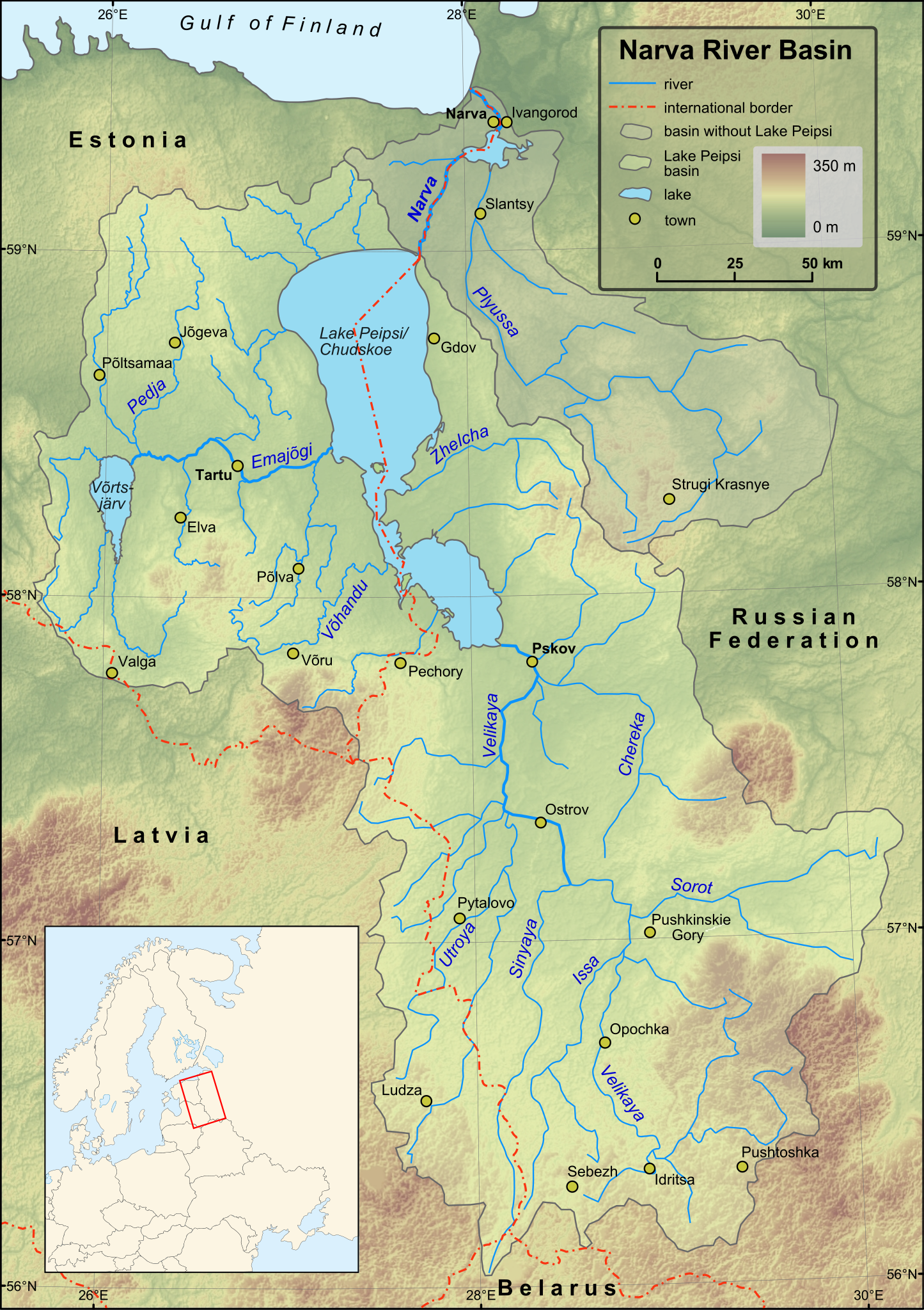
English: Map of Narva River and Lake Peipsi basins. Towns with population over 4000 (according to relevant Wikipedia lists) are included on the map. Terrain: embedded JPG. Projection: UTM Zone 35N |
| datum | |
| žórło |
Created in ESRI ArcMap and Inkscape using a map from [1] and some other maps for corrections.
Elevation data from Shuttle Radar Topography Mission. |
| awtor | Hannu |
| druhe wersije tuteje dataje | Magyar |
Licencowanje
| Ich, der Urheberrechtsinhaber dieses Werkes, veröffentliche es als gemeinfrei. Dies gilt weltweit. W někotrych krajach je to snano prawnisce njemóžno; jeli tomu tak je: Ich gewähre jedem das bedingungslose Recht, dieses Werk für jedweden Zweck zu nutzen, es sei denn, Bedingungen sind gesetzlich erforderlich. |
Wersije dataje
Klikń na wěsty čas, zo by wersiju dataje w tutym času zwobraznił.
| Čas | Wobrazowy napohlad | Rozeznaće | Wužiwar | Komentar | |
|---|---|---|---|---|---|
| aktualnje | 1. decembra 2009, 18:43 | | 743x1.053 (2,46 MB) | Hannu~commonswiki | minor updates |
| 28. nowembra 2009, 02:53 |  | 743x1.053 (2,44 MB) | Hannu~commonswiki | : | |
| 28. nowembra 2009, 02:35 |  | 743x1.053 (2,44 MB) | Hannu~commonswiki | text to path | |
| 28. nowembra 2009, 02:19 |  | 743x1.053 (2,06 MB) | Hannu~commonswiki | : | |
| 28. nowembra 2009, 02:14 |  | 743x1.053 (2,05 MB) | Hannu~commonswiki | new map | |
| 14. apryla 2009, 20:53 |  | 738x1.004 (959 kB) | Hannu~commonswiki | vector location map | |
| 17. januara 2009, 17:28 |  | 738x1.004 (957 kB) | Hannu~commonswiki | {{Information |Description={{en|1=Map of Narva River and Lake Peipsi basins.}} |Source=Created in Inkscape using a map from [http://www.ilec.or.jp/eg/lbmi/pdf/20_Lake_Peipsi_Chudskoe_27February2006.pdf]. Location ma | |
| 16. januara 2009, 18:18 |  | 738x1.004 (639 kB) | Hannu~commonswiki | {{Information |Description={{en|1=Map of Narva River and Lake Peipsi basins.}} |Source=Created in Inkscape using a map from [http://www.ilec.or.jp/eg/lbmi/pdf/20_Lake_Peipsi_Chudskoe_27February2006.pdf]. Minimap mad | |
| 16. januara 2009, 18:11 |  | 738x1.004 (529 kB) | Hannu~commonswiki | {{Information |Description={{en|1=Map of Narva River and Lake Peipsi basins.}} |Source=Created in Inkscape using a map from [http://www.ilec.or.jp/eg/lbmi/pdf/20_Lake_Peipsi_Chudskoe_27February2006.pdf]. Minimap mad |
Datajowe wužiwanje
Dataja so na slědowacych stronach wužiwa:
Globalne wužiwanje dataje
Slědowace druhe wikije wužiwaja tutón wobraz:
- Wužiwanje na af.wikipedia.org
- Wužiwanje na als.wikipedia.org
- Wužiwanje na ar.wikipedia.org
- Wužiwanje na ast.wikipedia.org
- Wužiwanje na azb.wikipedia.org
- Wužiwanje na be-tarask.wikipedia.org
- Wužiwanje na bg.wikipedia.org
- Wužiwanje na ca.wikipedia.org
- Wužiwanje na cs.wikipedia.org
- Wužiwanje na da.wikipedia.org
- Wužiwanje na de.wikipedia.org
- Wužiwanje na el.wikipedia.org
- Wužiwanje na en.wikipedia.org
- Wužiwanje na es.wikipedia.org
- Wužiwanje na fa.wikipedia.org
- Wužiwanje na fi.wikipedia.org
- Luokka:Narvanjoen vesistö
- Velikaja
- Pljussa
- Piusa jõgi
- Narvanjoen vesistöalue
- Luokka:Narvanjoen alue
- Narvanjoen alue
- Janja (Pljussa)
- Ljuta (Pljussa)
- Vjorduga
- Pljussan valuma-alue
- Kureja
- Pihkovanjoki
- Luokka:Velikajan valuma-alue
- Tšerjoha (joki)
- Haanjan ylänkö
- Alūksnen ylänkö
- Želtša
- Velikajan valuma-alue
- Peipsijärven valuma-alue
- Luokka:Peipsijärven valuma-alue
- Peipsijärven alue
- Luokka:Emajoen alue
- Luokka:Võrtsjärven valuma-alue
- Võhandu jõgi
- Emajoen valuma-alue
Globalne wužiwanje tuteje dataje pokazać