
Dataja:Czechoslovakia.png

Wulkosć tutoho přehlada: 800 × 407 pikselow. Druhe rozeznaća: 320 × 163 pikselow | 640 × 325 pikselow | 1.188 × 604 pikselow.
Wersija z wyšim rozeznaćom (1.188 × 604 pikselow, wulkosć dataje: 69 kB, typ MIME: image/png)

|
Dieses Bild des Typs Historical map sollte als Vektorgrafik im SVG-Format neu erstellt werden. Vektorformate haben zahlreiche Vorteile; weitere Information unter Commons:Media for cleanup. Wenn dir eine SVG-Version dieses Bildes vorliegt, so lade diese bitte hoch. Nach dem Hochladen der Datei ist diese Vorlage auf der aktuellen Bildbeschreibungsseite durch die Vorlage {{Vector version available}}, oder kürzer {{Vva}}, zu ersetzen. Es ist empfohlen die neue SVG-Datei „Czechoslovakia.svg“ zu nennen – dann benötigt die Vorlage vector version available (bzw. vva) keinen Parameter.
|
Zjeće
| wopis |
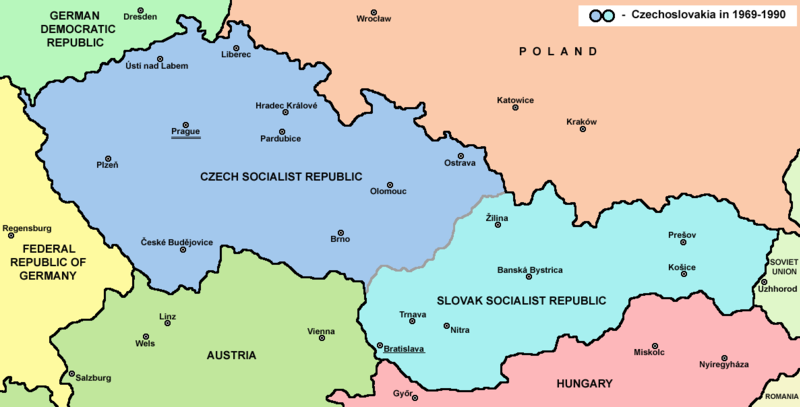
English: Map of Czechoslovakia in 1969-1990 |
| žórło | Swójske dźěło |
| awtor | PANONIAN |
| druhe wersije tuteje dataje | Abgeleitete Werke dieser Datei: |


Licencowanje
| |
Dieses Werk wurde (oder wird hiermit) durch den Autor, PANONIAN auf Wikimedia Commons , in die Gemeinfreiheit übergeben. Dies gilt weltweit. Falls dies rechtlich nicht möglich ist: |
References
Main reference:
- Map is created according to this external source: http://www.tcnj.edu/~guhr2/images/czechoslovakia.jpg Archivkopie in der Wayback Machine
Secondary references with similar maps:
- http://1.bp.blogspot.com/_Qe1wgxDiEdU/TGti_qWpeYI/AAAAAAAABo0/sSqAfIpQMuU/s1600/1213M_CS.gif
- https://jspivey.wikispaces.com/file/view/T010895A.gif/34419939/T010895A.gif
- http://media.web.britannica.com/eb-media/84/105684-050-0D8412E3.gif Archivkopie in der Wayback Machine
- http://www.gatheringofisrael.com/atlas/europe/slavic/CS_prague.gif
- http://collections.lib.uwm.edu/agsmap/images/lg/DSCN1455.jpg[toter Link]
- http://leccos.com/pics/pic/ceskoslovensko-_mapa_1950.jpg Archivkopie in der Wayback Machine
- http://www.math.sk/knor/GIF/mapa.gif
- http://ckpaji.sweb.cz/ceskoslovensko.jpg Archivkopie in der Wayback Machine
- http://www.power.szm.com/historia/mapa_TV_vysielacov_1978.jpg
Secondary references about Geo-political situation - published sources:
- The Times History of Europe, Times Books, London, 2002.
- Richard Overy, The Times History of the 20th Century, Times Books, London, 2004.
- The Times Atlas svjetske povijesti, Cankarjeva založba, Ljubljana - Zagreb, 1986.
- Istorijski atlas, Geokarta, Beograd, 1999.
- Školski istorijski atlas, Zavod za izdavanje udžbenika SR Srbije, Beograd, 1970.
- Povijesni atlas, Učila - Zagreb, Zagreb, 1971.
- Povijesni atlas za osnovnu školu, Kartografija - Tlos, Zagreb, 1975.
- Denis Šehić - Demir Šehić, Istorijski atlas sveta, Beograd, 2007.
Secondary reference about sizable cities:
|
|
Dieses Bild des Typs Map sollte als Vektorgrafik im SVG-Format neu erstellt werden. Vektorformate haben zahlreiche Vorteile; weitere Information unter Commons:Media for cleanup. Wenn dir eine SVG-Version dieses Bildes vorliegt, so lade diese bitte hoch. Nach dem Hochladen der Datei ist diese Vorlage auf der aktuellen Bildbeschreibungsseite durch die Vorlage {{Vector version available}}, oder kürzer {{Vva}}, zu ersetzen. Es ist empfohlen die neue SVG-Datei „Czechoslovakia.svg“ zu nennen – dann benötigt die Vorlage vector version available (bzw. vva) keinen Parameter.
|
Die Herstellung, Bearbeitung oder Freigabe dieser Datei wurde durch das Community-Budget von Wikimedia Deutschland unterstützt. Weitere Dateien, die mit Unterstützung von Wikimedia Deutschland hier veröffentlicht wurden, findest du in der Kategorie Supported by Wikimedia Deutschland. |
Wersije dataje
Klikń na wěsty čas, zo by wersiju dataje w tutym času zwobraznił.
| Čas | Wobrazowy napohlad | Rozeznaće | Wužiwar | Komentar | |
|---|---|---|---|---|---|
| aktualnje | 12. julija 2022, 16:45 | | 1.188x604 (69 kB) | Sebastian Wallroth | CROPPED |
| 12. februara 2017, 19:38 |  | 1.221x652 (69 kB) | PANONIAN | Reverted to version as of 11:00, 24 April 2011 (UTC) - why you uploading polish version over english one? upload polish version under different filename | |
| 9. februara 2017, 17:18 |  | 1.221x652 (57 kB) | Kelvin | Reverted to version as of 15:13, 9 February 2017 (UTC) | |
| 9. februara 2017, 17:17 |  | 1.221x652 (69 kB) | Kelvin | Reverted to version as of 11:00, 24 April 2011 (UTC) | |
| 9. februara 2017, 17:13 |  | 1.221x652 (57 kB) | Kelvin | Polish names of countries /Polskie określenia krajów | |
| 24. apryla 2011, 13:00 |  | 1.221x652 (69 kB) | PANONIAN | correction | |
| 23. apryla 2011, 12:27 |  | 1.221x652 (69 kB) | PANONIAN | improved version | |
| 11. decembra 2006, 01:31 |  | 1.200x624 (19 kB) | Severino666~commonswiki | Map of Czechoslovakia (self made) Category:Maps of Czechoslovakia Category:Maps of Czech history Category:Maps of the history of Slovakia Category:Maps of the history of Central Europe {{PD}} |
Datajowe wužiwanje
Dataja so na slědowacych stronach wužiwa:
Globalne wužiwanje dataje
Slědowace druhe wikije wužiwaja tutón wobraz:
- Wužiwanje na ang.wikipedia.org
- Wužiwanje na an.wikipedia.org
- Wužiwanje na ar.wikipedia.org
- Wužiwanje na azb.wikipedia.org
- Wužiwanje na az.wikipedia.org
- Wužiwanje na ba.wikipedia.org
- Wužiwanje na bcl.wikipedia.org
- Wužiwanje na be-tarask.wikipedia.org
- Wužiwanje na be.wikipedia.org
- Wužiwanje na bg.wikipedia.org
- Wužiwanje na bn.wikipedia.org
- Wužiwanje na br.wikipedia.org
- Wužiwanje na bs.wikipedia.org
- Wužiwanje na ca.wikipedia.org
- Wužiwanje na cv.wikipedia.org
- Wužiwanje na da.wikipedia.org
- Wužiwanje na de.wikipedia.org
- Wužiwanje na dsb.wikipedia.org
- Wužiwanje na el.wikipedia.org
- Wužiwanje na en.wikipedia.org
- Czechoslovakia
- History of Slovakia
- History of Czechoslovakia (1948–1989)
- History of Czechoslovakia (1989–1992)
- Economy of communist Czechoslovakia
- History of Czechoslovakia
- Dissolution of Czechoslovakia
- Czechoslovak Socialist Republic
- Portal:Slovakia
- She Grazed Horses on Concrete
- Rugby union in Czechoslovakia
Globalne wužiwanje tuteje dataje pokazać