
Dataja:Un-croatia.svg

Wersija z wyšim rozeznaćom (SVG-dataja, zakładna wulkosć: 900 × 666 pikselow, datajowa wulkosć: 892 kB)
Zjeće
| wopis |
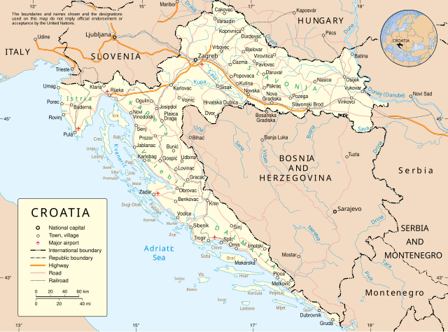
English: Map of Croatia |
| datum | June 2004 converted to SVG date of upload |
| žórło | Derived from UN Map of Croatia converted to SVG by me |
| awtor | United Nations Cartographic Section. |
| druhe wersije tuteje dataje |
|


Licencowanje
| Dieses Bild zeigt eine Karte, die von einer Karte der Vereinten Nationen (UN) abgeleitet wurde. Wenn nicht anderes ausdrücklich angegeben ist, können UN-Karten als gemeinfrei angesehen werden. Dies gilt weltweit. Einige UN-Karten haben besondere urheberrechtliche Bestimmungen, die auf den Karten selbst angegeben sind.
UN-Karten sind prinzipiell quelloffen (open source) und können frei, beispielsweise auch für die Erzeugung eigener Karten, verwendet werden. Die UN verlangen jedoch, dass in diesem Fall der Name, das Logo und die Referenznummer der Vereinten Nationen aus der modifizierten Karte gelöscht werden. Die Verantwortung für den Inhalt der abgeleiteten neuen Karte liegt bei dem Autor. In der abgeleiteten Karte kann, wenn gewünscht, ein Hinweis in der folgenden Art aufgenommen werden: Basierend auf einer Karte der Vereinten Nationen … (Kartenname, Kartennummer, Revisionsnummer und Datum). |
 |
Wersije dataje
Klikń na wěsty čas, zo by wersiju dataje w tutym času zwobraznił.
| Čas | Wobrazowy napohlad | Rozeznaće | Wužiwar | Komentar | |
|---|---|---|---|---|---|
| aktualnje | 8. apryla 2009, 03:50 | | 900x666 (892 kB) | DooFi | According to the UN-Map-Template "the UN name and reference number should not appear on any modified map". I deleted that information from the SVG as well as the border and also fixed some more ugly kerning errors |
| 8. apryla 2009, 00:29 |  | 903x695 (823 kB) | DooFi | Readable resolution, fixed 'A' in "HERZEGOVINA" and very little optimization | |
| 25. nowembra 2008, 20:30 |  | 602x461 (562 kB) | RaviC | {{Information |Description={{en|Map of Croatia}} |Source=Derived from [http://www.un.org/Depts/Cartographic/map/profile/croatia.pdf UN Map of Croatia] converted to SVG by me |Author=United Nations Cartographic Section. |Date=June 2004 converted to SVG dat |
Datajowe wužiwanje
Njejsu strony, kotrež tutu dataju wužiwaja.
Globalne wužiwanje dataje
Slědowace druhe wikije wužiwaja tutón wobraz:
- Wužiwanje na ar.wikipedia.org
- Wužiwanje na ba.wikipedia.org
- Wužiwanje na bg.wikipedia.org
- Wužiwanje na ceb.wikipedia.org
- Wužiwanje na de.wikipedia.org
- Wužiwanje na dsb.wikipedia.org
- Wužiwanje na en.wikipedia.org
- Wužiwanje na frr.wikipedia.org
- Wužiwanje na fr.wikipedia.org
- Wužiwanje na gn.wikipedia.org
- Wužiwanje na haw.wikipedia.org
- Wužiwanje na hu.wikipedia.org
- Wužiwanje na id.wikipedia.org
- Wužiwanje na it.wikipedia.org
- Wužiwanje na ja.wikipedia.org
- Wužiwanje na jbo.wikipedia.org
- Wužiwanje na kaa.wikipedia.org
- Wužiwanje na kk.wikipedia.org
- Wužiwanje na krc.wikipedia.org
- Wužiwanje na ln.wikipedia.org
- Wužiwanje na mi.wikipedia.org
- Wužiwanje na nov.wikipedia.org
- Wužiwanje na pam.wikipedia.org
- Wužiwanje na pap.wikipedia.org
- Wužiwanje na pms.wikipedia.org
- Wužiwanje na roa-rup.wikipedia.org
- Wužiwanje na ru.wikipedia.org
- Wužiwanje na sm.wikipedia.org
- Wužiwanje na sq.wikipedia.org
- Wužiwanje na sr.wikipedia.org
- Wužiwanje na tt.wikipedia.org
- Wužiwanje na vi.wikipedia.org
- Wužiwanje na war.wikipedia.org
- Wužiwanje na wo.wikipedia.org
- Wužiwanje na zea.wikipedia.org