
Dataja:Map-balkans-vlachs.png
Za tutu dataju žane wyše rozeznaće njeje.
Map-balkans-vlachs.png (440 × 337 pikselow, wulkosć dataje: 71 kB, typ MIME: image/png)

|
Dieses Bild des Typs Linguistic map sollte als Vektorgrafik im SVG-Format neu erstellt werden. Vektorformate haben zahlreiche Vorteile; weitere Information unter Commons:Media for cleanup. Wenn dir eine SVG-Version dieses Bildes vorliegt, so lade diese bitte hoch. Nach dem Hochladen der Datei ist diese Vorlage auf der aktuellen Bildbeschreibungsseite durch die Vorlage {{Vector version available}}, oder kürzer {{Vva}}, zu ersetzen. Es ist empfohlen die neue SVG-Datei „Map-balkans-vlachs.svg“ zu nennen – dann benötigt die Vorlage vector version available (bzw. vva) keinen Parameter.
|
Zjeće
| wopis |
Aragonés: Rechions con important población vlaca.
ܐܪܡܝܐ : ܦܢܝܬ̈ܐ ܕܒܗܘܢ ܢܬܡܠܠ ܠܫܢܐ ܪܘܡܢܝܐ.
العربية: Regions with green inhabited by significant Romanian population.
Български: Областите обозначени със зелено са население предимно с румънско население,с червено арумънско население а с жълто мъгленорумъни.
Bosanski: Područja označena zelenom naseljena značajnijom rumunskom populacijom.
Català: Mapa ètnic del romanès. Mapa dels Balcans amb les regions habitades per aromanesos en vermell.
Čeština: Mapa rozšíření Rumunštiny a jejích dialektů po Balkánu. Mapa balkánu, Arumuni zobrazeni červeně.
Dansk: Etnisk oversigtskort.
Deutsch: Die Dialekte des rumänischen Sprachareals im weitesten Sinn des Begriffes. Das Verbreitungsareal der vier walachischen (rumänischen) Sprachen der balkanromanischen Sprachgruppe. Das Verbreitungsgebiet der 4 balkanromanischen Sprachen. Das Verbreitungsgebiet der 4 Balkanromanischen (Walachischen) Sprachen. In den Gebieten außerhalb Rumäniens und Moldawiens ist oft die romanischsprachige Bevölkerung weniger zahlreich als die nichtromanische Mehrheitsbevölkerung. Verbreitung der Rumänen im weiteren Sinn des Begriffes (Walachen). Das istrorumänische Areal ist in einer hellen gelben Farbe dargestellt. Balkanromanische Sprachen rumänischer Zugehörigkeit im Sinne von 2., historischer Stand; die Gebiete außerhalb Rumäniens/Moldawiens zeigen nicht unbedingt an, dass in ihnen die Mehrheit der Bevölkerung rumänisch spricht/sprach. Das Verbreitungsgebiet der vier balkanromanischen (walachischen) Sprachen. In den Gebieten außerhalb Rumäniens und Moldawiens bildet die romanischsprachige Bevölkerung meistens eine Minderheit. Balkanromanische Sprachen im Sinne von a) 1. (Rumänische Idiome). Das Dakorumänische Sprachareal ist grün eingetragen; die Gebiete außerhalb Rumäniens/Moldawiens zeigen nicht unbedingt an, dass in ihnen die Mehrheit der Bevölkerung rumänisch spricht.
Ελληνικά: Η γεωγραφική εξάπλωση της Βλάχικης γλώσσας (με ροζ), καθώς και της βλάχικης διαλέκτου των Μογλενών (με πορτοκαλί) στην Μακεδονία, την Ήπειρο, την Αλβανία και την Π.Γ.Δ.Μ. Χάρτης των Βαλκανίων με τονισμένες τις περιοχές που κατοικούνται από Λατινόφωνους.
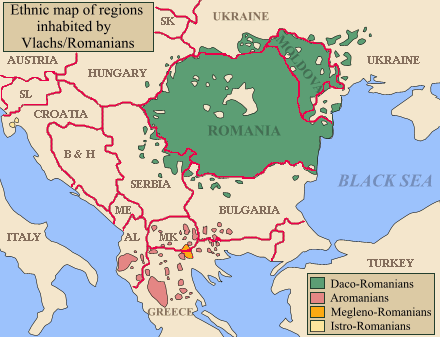
English: Map of the Balkans with regions inhabited by Romanians/Vlachs (Eastern Romance speakers) highlighted. Please note that not in all the regions highlighted, Romanian language is used by the majority of speakers. In some regions it only notes presence of a minority Romanian-speaking community. Regions inhabited by Daco-Romanian speakers in green, Aromanians in red, Megleno-Romanians in yellow, Istro-Romanians in pink (far west in modern day Croatia). |
| žórło | Self-published work by Olahus |
| awtor | Olahus |
| druhe wersije tuteje dataje | Evolution of the Eastern Romance languages and of the Wallachian territories from 6th century to the 16th century AD.jpg |

|
Dieses Bild (oder alle Bilder in dieser Kategorie) benutzt eingesetzte Bezeichnungen oder eine fest angefügte Legende in einer bestimmten Schrift oder Sprache und sollte möglichst in eine sprachneutrale Form gebracht werden. Dies würde es ermöglichen die Datei in allen Wikimedia Projekten und wichtiger noch, in allen Wikimedia Sprachen, zu verwenden.
|
Licencowanje
Ja, awtor tutoho dźěła, wozjewjam je z tym pod slědowacymi licencami:

|
Směće tutón dokument pod wuměnjenjemi licency GNU Free Documentation License, wersija 1.2 abo nowša wersija, wozjewjeneje wot załožby Free Software Foundation kopěrować, rozšěrjeć a/abo změnić; njejsu njezměnite wotrězki, njeje žadyn prědni a žadyn zadni wobalkowy tekst. Kopija licency je we wotrězku z titulom GNU Free Documentation License wobsahowana. |
| Tuta dataja je pod licencu Creative Commons Attribution-Share Alike 3.0 Unported licencowana | ||
| ||
| Tuta licencna marka je so tutej dataji jako dźěl licencneje aktualizacije přidała. |
Móžeš licencu swojeje wólby wubrać.
Wersije dataje
Klikń na wěsty čas, zo by wersiju dataje w tutym času zwobraznił.
| Čas | Wobrazowy napohlad | Rozeznaće | Wužiwar | Komentar | |
|---|---|---|---|---|---|
| aktualnje | 3. decembra 2022, 00:17 | | 440x337 (71 kB) | Sadko | Reverted to version as of 13:55, 26 February 2022 (UTC) There was no such territory at the beggining of the 20th century. Borders* should be presented neutrally. |
| 2. měrca 2022, 15:27 |  | 440x337 (26 kB) | InNeed95 | Reverted to version as of 06:57, 24 February 2022 (UTC)RV repeating Vandalism | |
| 26. februara 2022, 15:55 |  | 440x337 (71 kB) | TómasdeAquino2 | rv vandalism | |
| 24. februara 2022, 08:57 |  | 440x337 (26 kB) | Ahmet Q. | Reverted to version as of 15:55, 15 August 2019 (UTC)rv vandalism | |
| 16. nowembra 2021, 03:49 |  | 440x337 (71 kB) | TómasdeAquino2 | minor fix | |
| 15. awgusta 2019, 17:55 |  | 440x337 (26 kB) | Julieta39 | Correct ISO codes | |
| 24. apryla 2019, 10:52 |  | 440x337 (26 kB) | Julieta39 | Borders, countries | |
| 1. nowembra 2008, 16:00 |  | 440x337 (22 kB) | Olahus | {{Information |Description= |Source= |Date= |Author= |Permission= |other_versions= }} | |
| 23. septembra 2008, 21:47 |  | 440x337 (22 kB) | Skatefreak | Reverted to version as of 19:46, 23 September 2008 | |
| 23. septembra 2008, 21:47 |  | 440x337 (22 kB) | Skatefreak | {{Information |Description= |Source= |Date= |Author= |Permission= |other_versions= }} |
Datajowe wužiwanje
Dataja so na slědowacych stronach wužiwa:
Globalne wužiwanje dataje
Slědowace druhe wikije wužiwaja tutón wobraz:
- Wužiwanje na af.wikipedia.org
- Wužiwanje na am.wikipedia.org
- Wužiwanje na an.wikipedia.org
- Wužiwanje na arc.wikipedia.org
- Wužiwanje na ar.wikipedia.org
- Wužiwanje na arz.wikipedia.org
- Wužiwanje na ba.wikipedia.org
- Wužiwanje na bg.wikipedia.org
- Wužiwanje na br.wikipedia.org
- Wužiwanje na bs.wikipedia.org
- Wužiwanje na ca.wikipedia.org
- Wužiwanje na ce.wikipedia.org
- Wužiwanje na cs.wikipedia.org
- Wužiwanje na cv.wikipedia.org
- Wužiwanje na da.wikipedia.org
- Wužiwanje na de.wikipedia.org
- Wužiwanje na dsb.wikipedia.org
- Wužiwanje na el.wikipedia.org
Globalne wužiwanje tuteje dataje pokazać